'It was a near-death experience': How a California town blocked dangerous mudflows

 Getty Images
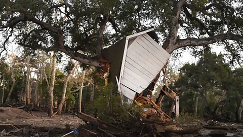
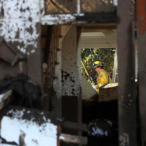
Montecito suffered a devastating mudslide in 2018. Now the community has rallied to try to make sure the same thing will never happen again.
Curtis Skene was asleep at 03:30 on 9 January 2018, when he heard the light rain turn into a downpour at his home in Montecito, California. A bright light drew the 64-year-old's attention out of bed, and within seconds, a car came crashing through his window, along with a wall of mud, sweeping everything away.
Skene managed to escape his house and cowered behind an olive tree on higher ground. He watched helplessly as entire eucalyptus trees, boulders the size of homes and 15ft (5m) of deep mud, the consistency of tar, passed through. It flowed roughly two miles (3.2km) from the foothills to the Pacific Ocean. The source of the light he'd seen was a neighbouring home that had caught fire.
"My life was saved by a millisecond. I can't explain it other than to say, I guess it was a near-death experience," Skene recalls.
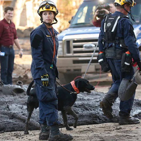
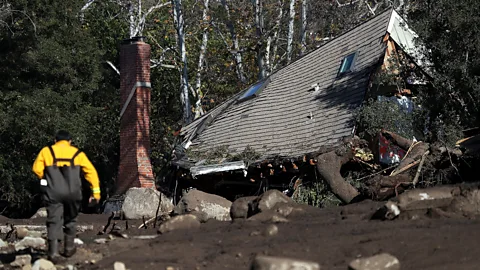
The 2018 debris flow killed 23 people, injured at least 167 and damaged 408 homes in the roughly 9,000 person town. Today, Skene is credited for spearheading the community's decision to rebuild in a way that didn't just erase evidence of the disaster, but aimed to make sure it would never recur.
 Getty Images
His and others' efforts in Montecito have become an emblem of how communities can come together after storms to rebuild a resilient town ahead of future climate-driven disasters.
An avalanche of mud
By 9 January 2018, residents of Montecito were sick of evacuating their homes. For months, homeowners had lived in the shadow of an encroaching wildfire that was inching up from the county to the south, burning more than 200,000 acres (81,000 hectares). While they ultimately escaped the inferno unscathed, by 9 January, many had only just moved their families and their pets back home. So, when orders came from local officials to evacuate once again due to anticipated heavy rains, the warnings were met with scepticism. Fire was known to be deadly, but rain? That was typically considered a blessing.
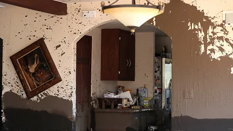
When the Sun came up the next morning, the rain's damage had rendered the community unrecognisable. Homes were swept off their foundations, creek crossings were carried away, cars were washed into the ocean and so much mud clogged the US 101 freeway that it was shut down for weeks.
Residents later learned that mudflows in the area weren't rare. In fact, two similar but less destructive incidents had happened in 1964 and 1971, but had faded from memory. A commissioned study of historical archives found that Montecito had actually been hit by four larger mudflows in the past 200 years.
Santa Barbara County, which includes the town of Montecito, is like most of Southern California in that its arid terrain makes it naturally vulnerable to shallow landslides and mudflows, which tend to happen on steeper slopes. The region is known as the land where water flows from the hills to the sea. Globally, climate change is exacerbating the intensity of extreme storms and altering rainfall patterns.
It became clear the 2018 debris flow wasn't likely to be the area's last.
"There used to be this thinking that fire season was summer and fall, and there was an interval of time before winter rainy season would begin. That whole paradigm has gone out the window," says Andrew Raff, environmental manager for the Santa Barbara County Flood Control District. "We have a year-round fire season now, where fire season essentially runs right into storm season. And we have this back-to-back potential for back-to-back emergencies."
Rebuilding differently
Montecito officials and residents took a multifaceted response to rebuilding after the 2018 debris flow, including a realisation that new safety initiatives had to be adopted.
"We have a community that's wedged between the mountains and the ocean that's subject to fire and intense storm events," says Raff. "What it really exposed is the need for sediment management and the need for emergency response work."
The Flood Control District started regularly walking debris basins that had been built in the 1960s after the previous damaging mudslides, and using drones to spot any debris needed for removal by bulldozers and trucks. Sediment would have normally washed to the sea on its own but now gets stuck in the basins. The county implemented a routine of removing some of the larger sediment flows to nearby beaches as part of an "emergency beach nourishment" programme, to help keep the basins clear. They are also in touch with other communities that might need sediment for uses such as a coastal dune restoration site.
 Getty Images
While it was at first met with criticism, according to Raff, because it de-beautified some of the community's beaches, the removal allowed the basins to stay open for future storms.
Other residents spearheaded the idea of building further protections against debris, including Skene.
"Before the event, I was a pretty typical Montecito resident. I never read the papers, never turned on local TV. If you asked me who my county supervisor was I would have told you I had no idea and I didn't know what they do," says Skene.
But he started setting up meetings and learned quickly. "I went into rebuilding saying there's nothing we can do about what happened in the past, but we need to go into recovery and we need to do it now," he says.
One Montecito street, Randall Road, had been hit particularly hard from the recent debris flow. Roughly 380,000 cubic yards of mud – the equivalent of 116 Olympic swimming pools – flowed down the San Ysidro Creek through the street, killing four people and rendering nearly every house unlivable.
At a community meeting, the county's Deputy Public Works Director and head of the Water Resources Agency Tom Fayram told residents about the seven debris basins that had been constructed in the late 1960s and designed to capture sediment, gravel and rocks, Skene recalled.
It was then that Skene came up with an idea to build another basin, this time on Randall Road.
 Getty Images
"I went up to him and said, 'Suppose I could get those seven properties for you, do you think that would make a good debris basin?'" says Skene. "Tom says to me, 'If you can get those properties you have no idea what a difference this would make'."
The project's projected cost was north of $21m (£15.5m). Undeterred, Skene surveyed Randall Road's former residents to see if they'd consider selling, and most were open to it. He raised $1.5m (£1.1m) from Santa Barbara residents to use towards studying the idea and helped establish relationships with local officials to see if they'd partner on building.
Santa Barbara County and the state agreed to work with the Federal Emergency Management Agency to build the Randall Road basin, according to Lael Wageneck, public information officer for Santa Barbara County. The final cost was $22.8m (£16.8m). Fema paid $11.7m (£8.6m) through its Hazard Mitigation Program Grant and construction on the basin broke ground in May 2021.
A separate solution
While Skene was working with county officials to find a way to finance the construction of a new basin, Pat McElroy was looking for a way to immediately protect Montecito residents from extreme rain events.
Recently retired as Santa Barbara's fire chief, McElroy knew how likely future wildfires were in the county, and had seen firsthand what rain could do to hillsides whose trees, roots and topsoil had been burned.
He was worried about the various riverbeds that flowed from the mountains behind Montecito. McElroy said locals trusted him because of his years of experience protecting the community from fire so a group approached him with a plea to look for ways to make their town safe again.
"We looked at a number of options that were there. And we were fortunate that we had some people that gave us quite a bit of money to start up. And basically they were saying, 'Go out there and find something,'" says McElroy.
He established the non-profit Project for Resilient Communities and raised more than $6m (£4.4m). The group settled on the idea of debris nets – metal structures that could catch any small or medium-sized debris that would come down from the foothills – and worked with geoengineers to draft a plan.
Metal nets are not uncommon in landslide or rockslide-prone areas. They are a frequent feature on narrow passages and cliff sides along Malibu's and Big Sur's Pacific Coast Highway and are sometimes referred to as debris retention systems.
McElroy's group opted to move quickly, relying on fundraising to purchase the nets and place them across riverbeds. Organisers personally reached out to the private landowners or family trusts that owned the property that the creeks crossed through to get permission to erect there.
"You had hundreds of homes gone, 23 people dead, billions of dollars in damage to local economy and infrastructure," he says of one reason why they decided to proceed so quickly, independently of county officials.
However, the county approved the group's permits to build and by 2019 the debris nets had been installed upstream of six rivers that flowed through Montecito. They ultimately recouped 75% of their costs through Fema grants, according to McElroy.
"What we were telling people is, if we don't do something, nobody's going to do anything. And we need to strike while the iron is hot," McElroy says.
Passing the first test
On the fifth anniversary of the Montecito debris flow the town once again experienced heavy rains. A total of 14cm (5.5in) accumulated and more than 164,000 cubic metres (215,000 cubic yards) of debris – the equivalent of a football field piled 10m (33ft) high with mud – flooded the creek that led to Randall Road, according to Wageneck.
But this time, the town was ready. All six debris nets collected sediment and one was at full capacity. McElroy considered it proof of concept. The nets had done what they were created to do – keep rocks and other objects from flowing onto streets and creating damage.
"To our mind, that was an incipient debris flow that was stopped, and that was also the opinion of our geologist," says McElroy.
 Getty Images
The debris basin on Randall Road had also just been finalised three months earlier in October 2022. After the storm passed, the basin was half full, according to Wageneck.
"I cannot overemphasise the importance of community participation," says Skene about getting the basin built.
California Governor Gavin Newsom visited the basin days later and thanked attendees. "I wanted to thank the community. I want to thank you for your pride and spirit. Thank you for having each other's back. There's no substitute for that," he said, according to a local paper.
In the autumn of 2023, the group removed the debris nets. The decision was controversial at the time, but the nets had only been permitted for five years. The belief was that the new basins would now do the work on their own.
"The nets were a private undertaking on private land without practical access or options to remove debris," said Wageneck. "The County's public protection work focused on constructing new basins, modifying others, and developing a Montecito Flood Control Master Plan to enhance community resilience."
Wageneck emphasised that the Randall Road and San Ysidro basins caught 20,000 cubic metres (26,000 cubic yards) of material during the 2023 storm alone, far more than the nets ever could have.
"For the debris basin operations to be efficient and effective, we need to have vehicles to access them and remove the material and take them where they need to go – and those nets are difficult to access, they require a helicopter to address the nets," says Wageneck.
In the years since the disaster, several other communities have taken lessons from Montecito.
McElroy says he's shared information on the nets with communities in Fresno and Santa Cruz after the Creek and CZU Lightning Complex fires burned in 2020. He also consulted on a net project for Los Angeles's Getty Museum to keep loose rocks and debris from falling into neighbours' property following a fire that had burned close by in 2019.
Carbon count
The emissions from travel it took to report this story were 0kg CO2. The digital emissions from this story are an estimated 1.2g to 3.6g CO2 per page view. Find out more about how we calculated this figure here.
Raff says he and others in his office have also had meetings with Los Angeles officials after the city experienced two deadly wildfires earlier this year. "I felt kind of honoured to be invited to give them our small county public works department's input. They've got a big workload on their hands. The threat is not over," he says.
Los Angeles has so far avoided the dramatic landslides that were feared after extensive wildfires in January 2025. Still, the county made preparations by putting out 20,000 sandbags and over a mile of concrete barriers.
"I would say that the Thomas fire and those mudflows are always in the back of my mind," says Sterling Klippel, a principal engineer at the Los Angeles Public Works Department. "You never want to see anything like that happen here in LA County."
Back up north, Montecito has new plans to erect another basin along a different creek. For Raff and other emergency and water officials, the 2018 disaster is still fresh. Thinking back about the impact the deaths had on the community still brings Raff to tears.
"I mean this idea of rainfall pattering on the roof and you cosy up with a book – that doesn't exist for flood control staff, rainfall pattering on the roof is not a relaxing sound. We're on the edge of our seats all winter long," he says. "Unfortunately, we don't get to design the storm season."
--
For essential climate news and hopeful developments to your inbox, sign up to the Future Earth newsletter, while The Essential List delivers a handpicked selection of features and insights twice a week.