The satellite that will 'weigh' world's 1.5 trillion trees

 ESA-CNES-ARIANESPACE
The world's rainforests are often referred to as the "lungs of the earth".
They store billions of tonnes of carbon and in doing so help to reduce the impacts of climate change.
But with more than one and half trillion trees, measuring exactly how much carbon they store has been virtually impossible, until now.
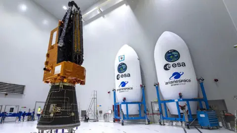
On Tuesday, the European Space Agency (ESA) successfully launched a first-of-a-kind satellite which uses a special radar system to reveal what lies beneath the canopy.
It is hoped it will help scientists better understand the importance of rainforests in storing carbon and the impact of deforestation.
The rocket took off from ESA's Kourou station in French Guiana and flying over the Amazon, one of the rainforests it will study.
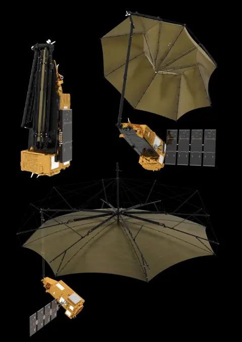
The satellite on board has been affectionately named "space brolly" for its giant 12m diameter antenna which will send out signals.
"We really want to interrogate these forests. We can actually look inside," Prof John Remedios, director of The National Centre for Earth Observation, which proposed the idea to ESA, said after the launch.
He said that it would be a major achievement "to actually know for the first time with high accuracy how much is actually in the Amazon, Congo, Indonesia".
The antenna is using P-band radar which has a very long wavelength - allowing it to see deeper inside forests and reveal branches and trunks obscured by the canopy.
"Most radars that we have in space today take wonderful images of icebergs, but when they look at forests they see the tops of the forest, the little twigs, the little leaves, they don't penetrate down into the forests," explained Dr Ralph Cordey, head of geosciences at Airbus.
"But what we found was that by using a much longer radar wavelength, we could see down into the depths of trees and forests," he said.
The 1.2-tonne satellite will use an approach not dissimilar to that used in a CT scan, and analyse slices through the trees on repeat passes to build up a picture of how much woody material is present.
It is this material that can be used as a proxy for the amount of planet-warming carbon dioxide stored.
Currently scientists have been measuring individual trees and trying to extrapolate, but this presents a "huge challenge" said Prof Mat Disney, professor of remote sensing, at University College London.
"Our current understanding is really patchy, because it's really, really difficult to measure," he said. "Essentially, what we're talking about is trying to weigh the amount of carbon that's stored in one and a half trillion trees across the tropics.
"Satellites are really the only way you can do that consistently."
On the ground measurements will continue to take place after the satellite is launched to verify the data it is sending back.
 ESA-CNES-ARIANESPACE
The satellite was built in the UK and first conceived by University of Sheffield academic Professor Shaun Quegan, but he said it was an international effort: "The mission is the culmination of decades of highly innovative work in partnership with some of the best scientists in Europe and the US."
Despite decades of testing, the deployment of the satellite has many challenging stages beyond the rocket launch.
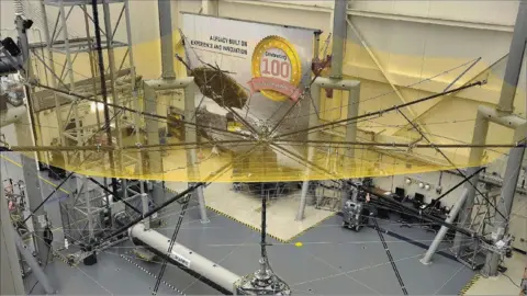
"Certain things on the satellite are big, that includes its big 12-metre, deployable antenna. It's a bit like deploying an umbrella in space, only a very big one, so we will be looking for that to happen smoothly," said Dr Cordey.
Airbus brought in engineers from the American company L3Harris Technologies to their site in Stevenage to oversee the construction of the antenna-reflector.
L3Harris are specialists in these large, unfurlable systems - expertise which is not currently possessed in Europe.
 L3 Harris Technologies
The team is hoping to produce the first maps within six months, and will then continue to gather data for the next five years.
These annual maps will not only show how much carbon is stored but how much is being lost through deforestation.
"The kind of observations that we've had for 50 years from [other] satellites like Landsat are affected very heavily by clouds. And in tropical regions, we have clouds a lot of the time, so you may not see a chunk of tropical forest," said Prof Disney.
Another advantage of the longer wavelength of the Biomass satellite is that it can penetrate clouds giving a consistent, comparable view of a forest from one year to the next.
It is this outcome which has motivated the scientists who have worked on the project for more than 20 years.
"It's exciting, because it's going to tell us about how something that we perhaps take for granted," said Dr Cordey. "Our forests, our trees, how they are contributing to the processes which govern our planet, and in particular, the processes behind climate change which are so important to us today and for the future."

Sign up for our Future Earth newsletter to get exclusive insight on the latest climate and environment news from the BBC's Climate Editor Justin Rowlatt, delivered to your inbox every week. Outside the UK? Sign up to our international newsletter here.