The great iceberg hunt on Canada's epic new road

 Alamy
AlamyA sweeping new highway – nearly 25 years and C$1bn in the making – is reshaping life in Newfoundland and Labrador and opening up Canada's iceberg coast.
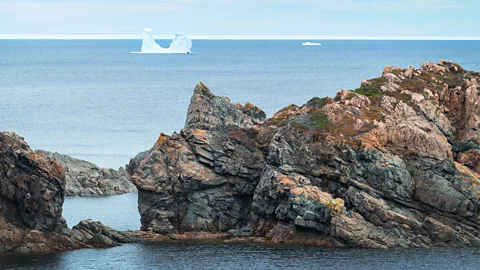
Standing on a windswept outcrop on the island of Newfoundland's northern coast, I scanned the churning, blue-steel sea for icebergs. Somewhere beyond the restless waves lay the glaciers of Greenland and the ice fields of Arctic Canada. I was hoping to glimpse their offspring – behemoths calved from ancient ice shelves, carried south over two or three years by the Baffin Island and Labrador Currents into a region known as Iceberg Alley, a stretch of water between the southern coast of Labrador and the south-eastern shore of Newfoundland.
Squinting, I caught sight of a solid white shape; a still patch in the Labrador Sea. For a heartbeat, I thought I'd found one. Then it vanished in a burst of froth and spray.
My husband Evan and I continued along the rocky trail, ducking out of the wind behind a patch of tangled tuckamore. Made up of hardy, slow-growing boreal trees like balsam fir and black spruce, the wind-contorted forest barely reached my chin. Up ahead, Evan pointed out an osprey, fragile and exposed, as it spread its wings to dry. Beyond it, the ocean vista was punctuated by sea stacks, sculpted cliffs and a small, curved bay dotted with abandoned homes.
Despite the blue sky and warmth of late spring, life in Newfoundland and Labrador demands ingenuity and resilience. Like the meadow grasses and wildflowers clinging to the salt-laced soil, the people here have only ever held a precarious grip on this wondrous place. I inhaled deeply, marvelling at the austere beauty – then another glint of white caught my eye.
"Only a boat," Evan said, following my gaze.
 Getty Images
One week into a two-week road trip across Newfoundland, we had yet to spot an iceberg. They were out there; each morning, the iceberg-tracking map showed giants drifting to our west. The problem was geography. Newfoundland and Labrador's pleated coastline means a berg 50km away by water could be 400km by road – and this season, they were clustered in the southern bays of Labrador, a region that was, until recently, among the hardest to reach.
The Open Road
The Open Road is a celebration of the world's most remarkable highways and byways, and a reminder that some of the greatest travel adventures happen via wheels.
In a place where the ocean long served as the main highway, roads came late. When Newfoundland joined Canada in 1949, there were just 195km of pavement for a province with more than 29,000km of coastline. The obvious solution was to build roads, with the goal of improving access to jobs, schools and healthcare. But this came at a cost. Building takes time and the initial roadways bypassed many small coastal settlements, leading to the abandonment of more than 300 outport communities.
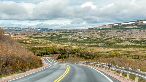
"But a new road can change everything," Keith Pike, the city manager in Red Bay, an outport on Labrador's southern coast told me, after I'd continued my trip west. Just 80km north of the Quebec border and the Newfoundland-Labrador ferry terminal in Blanc-Sablon, Red Bay hugs the edge of the Strait of Belle Isle. Not long ago it also marked the end of the old gravel road; isolation that forced Pike to leave the place his family had called home for generations. But with the recent completion of the Trans-Labrador Highway – known as Expedition 51 for the latitude it follows – he has returned, and is hopeful others might do the same.
The 1,200km highway, nearly 25 years and C$1bn in the making, threads across Labrador's sweeping terrain, linking inland towns, distant outports and more than 9,000 years of human history. It's the kind of rugged drive that road-trippers dream of, forming a loop through Quebec, Newfoundland and Labrador, Nova Scotia, New Brunswick and even touching into the US and the French islands of St Pierre and Miquelon. While only a few people are expected to drive the entire circuit, Pike sees the road's greatest legacy in its promise. "People like me are able to come home because of the opportunities it's creating," he said.
 Diane Selkirk
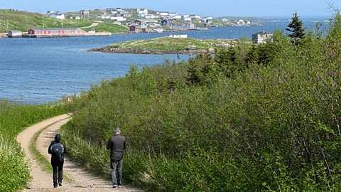
In simple terms: the places Newfoundlanders and Labradorians call home have proven to be alluring to travellers looking for wild landscapes and meaningful cultural encounters. And along Expedition 51, visitors aren't just welcome, they're needed. It's a place where thoughtful tourism can help sustain places that have endured against the odds.
In Indigenous communities, the road is already sparking new ventures. Barbara Young, marketing coordinator for the Newfoundland and Labrador Indigenous Tourism Association, says local entrepreneurs are building businesses rooted in tradition. From guided hikes with Kaumanik Adventure Tours in Port Hope Simpson to Inuit art at Caribou Place in Mary's Harbour, these stops invite travellers to engage with cultures that have thrived here since time immemorial.
History, too, is central to Red Bay's story. A major Basque whaling station in the 1500s, the long-abandoned settlement grew out of the whale oil that once lit Europe's lamps. Today, Parks Canada and the townspeople are betting on the new highway drawing more visitors to the Red Bay National Historic Site. They've invested in a new interpretive centre, expanded boardwalks through Saddle Island's archeological sites and improved hikes like the Boney Shore Trail where whale bones still line the coast.
More like this:
• Canada's remote (but accessible) dark-sky sanctuary
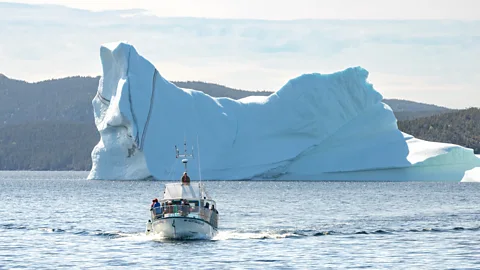
As Evan and I chased icebergs, I realised Expedition 51 is also opening more of Iceberg Alley. New operators like Whaler's Quest Ocean Adventures now offer boat tours out of Red Bay, often with a side of traditional music by locals like Pike.
It may seem ironic that a seafaring province closely associated with the Titanic – just one of the more than 600 documented ship-iceberg collisions that have claimed more than 3,400 lives over the past two centuries – is embracing iceberg tourism. Back when most communities relied on the cod fishery, the massive bergs that drifted by each spring were deadly navigational hazards. But as coastal populations dwindled, the icy giants offered a glimmer of hope.
 Getty Images
Twillingate was one of the first to embrace the shift. Straddling two islands linked by a narrow tickle, and just 100km from Gander's airport, Twillingate gained road access in the 1970s. After the cod fishery collapsed in the 1990s, the town began to reinvent itself. Locals transformed old footpaths – once used to reach now-abandoned communities or favourite berry-picking patches – into hiking trails, launched iceberg tours and started businesses like Great Auk Winery, which uses iceberg water in its products.
Drawn to the now-famous town, Evan and I continued our daily scan of iceberg-tracking sites. Even though the icebergs drifted stubbornly west, locals helped us build a very Newfoundland bucket list. We were directed to puffin and whale lookouts, tipped off about the perfect fog-free window for visiting the lighthouse, told where to buy fresh-caught lobster, sent to see several root cellars and urged to visit the Beothuk Interpretation Centre to learn about the tragic demise of the Indigenous Beothuk people.
On the hiking trails, we reflected on the empty outports and watched for untracked icebergs.
"They've given people a reason to come home," an employee at Great Auk Winery told us as we sampled a flight of wines. The bakeapple iceberg wine – infused with golden-orange berries handpicked from nearby bogs – offered a honeyed apricot note. Blended with harvested iceberg water, it showcased how seafaring traditions are being reimagined. We bought a bottle; even if we didn't spot one of the elusive giants, we could still savour the taste of 50,000-year-old water.
In a typical year, 700 to 800 icebergs drift through Iceberg Alley; some years, none appear at all. I had nearly given up when I glimpsed my first one at Red Bay. Floating offshore from Expedition 51, the glittering hulk told the story of a snowflake's improbable journey from cloud to glacier to sea to tourist attraction. It had taken thousands of years to get here – but without the new highway, I wouldn't have seen it at all.
--
If you liked this story, sign up for The Essential List newsletter – a handpicked selection of features, videos and can't-miss news, delivered to your inbox twice a week.