'It was a hellscape': The challenge of evacuating Los Angeles during wildfires
 Getty Images
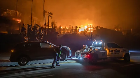
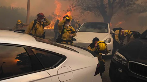
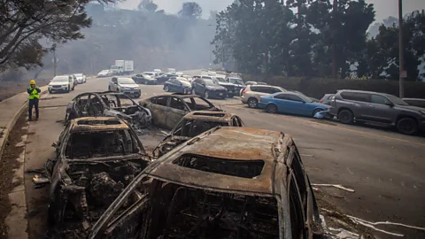
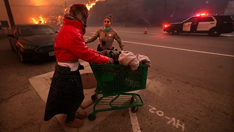
LA residents rushing to flee wildfires this week faced choke points, gridlock and the tough decision of whether to abandon their cars to the fire.
What's thought to be the most destructive fire in Los Angeles' history is ravaging the city. At the time of writing, more than 180,000 people had fled their homes and 10 people have lost their lives.
But ahead of the smoke, flames and homes left smouldering in ruins, another story has unfolded again and again as the fires have spread – one of evacuation and chaos.
Residents have often been quick to respond to the warnings and evacuation orders issued by the authorities in LA, with some even leaving their homes before they were told to. When they have tried to leave, however, they rarely get very far.
As residents of Pacific Palisades fled their homes on Wednesday, the Pacific Coast Highway, the main road towards Malibu, quickly became gridlocked. Some people abandoned their cars, opting instead to try to escape the blaze on foot. Bulldozers had to clear abandoned vehicles to make way for firefighting crews. One resident told the BBC that he was stuck in a traffic jam for two hours while trying to escape the Palisades fire.
Maryam Zar experienced this bottleneck when she evacuated her home in Pacific Palisades as a wildfire tore through her neighbourhood. "Nobody was moving at all for a good half an hour and I was stuck on a road for 45 minutes," Zar, former chair of the Pacific Palisades Community Council, tells the BBC. She had to evacuate three times in the space of 24 hours as high winds fuelled the flames and swept the fires through neighbourhoods at alarming speed. "It's complete devastation. It's a hellscape."
Why the LA fires spread so quickly
Decades of drought, followed by heavy rainfall in recent years and then a return to dry conditions this autumn and winter provided fuel for the inferno, while powerful Santa Ana winds quickly dried out vegetation and spread the flames. These five images explain why the LA fires have been so intense and grown so rapidly.
Compounding this problem is the layout of the area's transport network. "There are only two or three roads; two major arteries and one tiny windy little road that gets you out of Palisades," says Zar. "Our big concern [has] always [been] that the roads will become gridlocked, we'll be stuck and the fire will chase us down. To some degree, I think people were afraid that was happening yesterday, but the reality is that everybody evacuated."
Similar chaotic scenes unfolded in Hollywood on Thursday as the flames from the Sunset fire closed in on neighbourhoods there. Many of the roads near the blaze quickly became gridlocked with traffic.
LA is not an easy city to flee in an emergency, experts say. Narrow, winding roads are common in LA's affluent suburbs and can hinder quick exits, says Chris Nevil, public information officer at MySafe:LA, a non-profit that works to promote fire prevention and disaster readiness in Los Angeles.
"There's not a lot of ways in and out of the Palisades and that caused tremendous problems. It was a hot mess," he says. "Many of the roads [in LA] go back to a time before SUVs, when families had one smaller car and not necessarily the behemoths that we all drive around, especially in these relatively affluent hillside areas."
Despite the risks, these neighbourhoods remain highly popular. "People want to live in these secluded peaceful places where they're in touch with nature, but that comes with built-in risk," he adds.
 Getty Images
Natalie Enclade, executive director of Buildstrong America, an organisation working to increase resilience across the US, says the road network was put under severe strain by the emergency. "With tens of thousands of residents attempting to flee simultaneously in a hasty evacuation, the major roadways became severely congested. This gridlock significantly slowed the evacuation process, putting more lives at risk."
But challenges in evacuating cities in California are nothing new, Enclade notes. When the wildfire known as the "Camp Fire" ravaged areas in northern California in 2018, the destruction of infrastructure "decreased communication capacity, hindering evacuation efforts", she says. During another wildfire the year before, debris blocked the single road that was the only exit for an entire community, she adds.
"The largest factor contributing to these events is insufficient resources," says Enclade. "Local agencies and resources are quickly overwhelmed by the speed and scale of these megafires."
The LA County fire chief said on Wednesday that there are not enough firefighters to address fires "of this magnitude".
 Getty Images
LA's streets are congested on a normal day, but "it really is a different beast when you have everybody trying to flee after an earthquake or a wildfire," says Geoff Boeing, assistant professor at the University of Southern California's (USC) urban planning department.
"A lot of the street networks [in LA] have choke points built into them," says Boeing. There are a variety of reasons for this. "It could be the terrain or the 'aesthetics of exclusivity', especially in gated communities where there's one way in and out," he says.
A 2024 study by Boeing and his colleagues found that the design of street networks plays an important role in increasing a city's resilience to disasters.
Boeing's study simulated more than 2.4 billion trips across 8,000 urban areas in 178 countries, while also simulating disruption events such as floods, earthquakes and targeted attacks. Boeing concluded that street networks with higher connectivity and fewer choke points were less vulnerable during disruption events.
"By better connectivity, we are referring to how many streets there are connected to each intersection. In a late-20th Century American suburb, you'll see a lot of dead ends, meaning there's only one street connected to that node, or three-way intersections, where you have to choose which way to go. These all reduce the connectivity of the network and reduce your choices and routing," says Boeing. "LA can be pretty bad. It's even worse in places like suburban Phoenix or Las Vegas, where you have a super-block with just one or two entrances."
The future is in limbo for composer Denis Hannigan. On Wednesday, he was forced to evacuate his residence in Topanga Canyon, a community tucked away in the now-burning hills of the Santa Monica Mountains. Hannigan woke up on Thursday morning to learn the flames now pose a direct threat to his house.
Infrastructure poses a major hurdle to safety for his remote community, with old, narrow roads that barely get the job done even in normal circumstances. "We only have one road in and out, and we're almost semi-rural, they're mountain roads. The road in my neighbourhood is only about one and a half lanes. You can't get two cars by sometimes," he says. "They've already been closing roads to residents only during fire weather to address the kind of cluster that could trap people, which is a new thing after the last three or four fires," he says.
 Getty Images
And when the threat of fires comes, as it does so often, officials shut off electricity. "Where we live you cannot communicate without power. You end up with thousands of people who can't get up-to-date information about whether there's a fire or not," Hannigan says. "From an urban planning perspective, it all has to be thought out if we're going to keep people safe, down to the last detail."
Part of the problem in these areas is the slow but steady pace at which they're built up, according to Frank Frievalt, director of the Wildland-Urban Interface Fire Institute at California Polytechnic State University.
"When you're building roads, for example, you're typically designing systems for daily use and engineering in some capacity of peak usage and surges. We know the roads are busier at certain times of day, and you factor that in," Frievalt says. "But when you have these large areas with incremental development over time, it starts to add up. It's hard to understand how each addition and construction project affects the larger system."
That is, until disaster strikes. "With a fast-moving natural catastrophe, it reveals the stresses to the system that you don't see every day," he says.
It's difficult to address the problems of strained infrastructure even when the issues are clear. "You don't just incrementally put in two more inches on Topanga Canyon Road, for example. You don't get to keep up with the stresses of development in real time," Frievalt says. "There's a logistical and financial time lag. You save up until you can invest in a larger capital development, and often the growth rate outruns your ability to undertake investments."
According to Frievalt, if history offers any indication, the coming few weeks and months will see the public going through the stages of grief. "With climate change, we're dealing with the pain of understanding that the future we imagined for ourselves is lost. At the very minimum, we need to have hard discussions about places that we know have the conditions for extremely catastrophic outcomes.” Frievalt says. “Are going to build back to more a resilient but dramatically more expensive standard? Or are we going to say we just can't allow development there? These are tough decisions, but we have to make them, because this is going to happen again."
Retrofitting existing infrastructure and roads is difficult to do, says Boeing. "It tends to cost a lot of money." It can also be easy to disconnect an entire street network by removing a few key nodes that link neighbourhoods together, Boeing concluded in his study. "Even otherwise dense, connected Amsterdam, for example, can be easy to disconnect by targeting its chokepoints, like canal bridges."
One way to aid evacuation in an emergency is to improve public transport. Research shows that public transport can help evacuate large numbers of people in a short space of time. A 2011 study by researchers at the University of Toronto found that public transport in Toronto could evacuate 1.34 million people within two hours.
"We have a very large bus network in LA. It's just incredibly inconvenient because those buses have to go in the same traffic as everyone else," says Boeing. “We don't have a dedicated bus lane. If we did, a lot of people would switch."
A 2024 study by researchers at the University of Alberta recommended that evacuation plans following extreme weather events include special bus routes for disasters and free public transport. "Most North American jurisdictions still lack a fundamental understanding of equity-centred needs or evacuation plans that incorporate public transit use," the researchers said, noting that vulnerable communities, including people with disabilities, older adults and lower-income households, often rely on public transport and lack access to private vehicles.
But Boeing says that even with investment, it may be difficult to encourage some LA residents to rely on public transport. "Driving everywhere in your single occupancy vehicle [offers] privacy, safety, convenience and perception… it's part of the LA lifestyle."
As a 40-year resident of Topanga, it's not Hannigan's first time facing a fire. "At my age it gets to 'been there, done that'. Eventually, you reach the point where your house might burn down so many times that you get spiritual about it. It's just a house," he says.
--
This article was updated on 10/01/2025 to include the latest death toll and evacuee figures.
For essential climate news and hopeful developments to your inbox, sign up to the Future Earth newsletter, while The Essential List delivers a handpicked selection of features and insights twice a week.
